Climate Matters•July 1, 2024
July Warming and Global Temperature Update
KEY CONCEPTS
The planet’s record heat streak continues as we head into July — the hottest time of year for most of the U.S. And it’s only getting hotter as our climate warms.
Since 1970, July has warmed in 93% of 243 U.S. cities — by 2.4°F on average.
Graphics for 243 U.S. cities show July warming trends and recap the hottest, coolest, and wettest July 4th on record in each location.
July days and nights will continue to heat up if high levels of carbon pollution continue, amplifying health risks during the hottest time of year.
The good news is that we have many options to cut carbon pollution. We review signs of progress toward a cleaner, safer future.
Global update: 12 months of record-breaking heat
The planet’s record heat streak continues. May 2024 marked 12 consecutive months of record-breaking global surface air temperatures. Final data for June 2024 will be available in the coming days, and is likely to confirm a 13th month in this string of record temperatures.

The global oceans are feeling the heat, too. May 2024 also marked 14 consecutive months of record-breaking global sea surface temperatures. Record ocean heat has contributed to NOAA’s outlook for an above-normal 2024 Atlantic hurricane season.
July is here and so is the heat
July is typically the hottest month of the year for the contiguous U.S. Most places across the country experience their single hottest day of the year in July as well.
And July’s peak heat is only getting hotter as summers heat up across the country.

Climate Central analyzed July temperature data from 1970 to 2023 for 243 U.S. locations:
July average temperatures have warmed in 93% (225) of all locations analyzed.
Across those 225 locations, July temperatures have increased on average by 2.4°F since 1970.
July has warmed by at least 3°F in over one in every four cities analyzed.
The Northwest (3.9°F), Southwest (3.3°F), Northeast (2.6°F), and Northern Rockies and Plains (2.6°F) have experienced above-average July warming since 1970.
Check out your city’s graphic to see July warming trends and records for the hottest, coolest, and wettest July 4th in your area.
Warming climate, hotter July days and nights
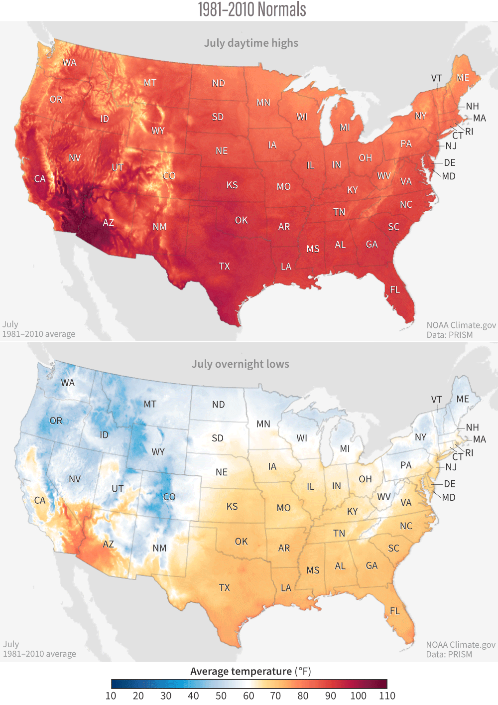
July warming since 1970 is part of a longer warming trend. Across the contiguous U.S., July daytime highs have warmed at a rate of 0.88°F per century since records began in 1895. July overnight lows have warmed about twice as fast over that same period — part of a dangerous trend of hotter summer nights.
These trends will continue into the future if heat-trapping pollution continues, according to analysis from NOAA.
If energy demand continues to be met mainly with fossil fuels in the coming decades, the resulting high levels of carbon pollution would push July day and night temperatures to hotter and riskier levels for health, agriculture, wildlife, and more.
Progress toward a cleaner, cooler, safer future
The good news is that we have many options to cut carbon pollution from energy, transportation, agriculture, and more. Every fraction of a degree of avoided warming counts toward a safer future.
Warming Across Generations shows how much warming younger generations in 242 U.S. cities could experience over their lifetimes if carbon pollution either continues, or is cut rapidly.
The U.S. has set a national goal to reduce heat-trapping emissions 50% below 2005 levels by 2030. Although the U.S. has made some progress toward this goal, the pace is not fast enough to meet national targets by 2030. But there are signs of progress toward a cleaner and safer future:
Private and public U.S. investment in clean technologies like solar, wind, and battery storage has never been higher — more than tripling from 2018 to 2023.
A Decade of U.S. Solar Growth and A Decade of U.S. Wind Growth shows that the U.S. produced enough solar and wind power in 2023 to power 61 million homes — reflecting a 10-year growth curve in both technologies at the state and national levels.
State Solar and Wind Boom to Bring U.S. Toward Climate Targets shows that, by 2035, solar and wind are expected to make up more than 50% of energy capacity in 46 states under current policies.
Climate Solutions in Every State reviews options to quickly reduce emissions in each U.S. state’s top-emitting sector.
LOCAL STORY ANGLES
Did climate change influence hot days or nights today?
Climate Central’s Climate Shift Index map tool can answer this question in real time. The map shows which parts of the world are experiencing a strong influence of climate change on daily high, low, and average temperatures, every day.
How is extreme heat affecting public health in your local area?
Check out HeatRisk, an interactive map tool from the National Weather Service now available for the contiguous U.S. This color-numeric index shows current and forecast risk of daily local heat-related impacts. The Centers for Disease Control and Prevention’s Heat and Health Tracker maps heat-related illnesses at the census tract level in real time. Use the National Integrated Heat Health Information System’s Heat Equity Mapper to explore the burden of extreme heat at the census tract level. Check the U.S. Department of Health and Human Services monthly Climate and Health Outlook for extreme heat outlooks in your region throughout the summer.
FIND EXPERTS
Submit a request to SciLine from the American Association for the Advancement of Science or to the Climate Data Concierge from Columbia University. These free services rapidly connect journalists to relevant scientific experts.
Browse maps of climate experts and services at regional NOAA, USDA, and Department of the Interior offices.
Explore databases such as 500 Women Scientists, BIPOC Climate and Energy Justice PhDs, and Diverse Sources to find and amplify diverse expert voices.
Reach out to your State Climate Office or the nearest Land-Grant University to connect with scientists, educators, and extension staff in your local area.
METHODOLOGY
Local July 4th climate extremes and average July temperatures from 1970 to 2023 were retrieved from the Applied Climate Information System for each station’s period of record. Climate Central's local analyses include 247 stations. Data summaries based on linear trends include only 243 stations due to large data gaps in the following four: Dothan, Ala.; Hazard, Ky.; Twin Falls, Idaho; and Wheeling, W.Va.