News•October 24, 2014
Picture This: Wavy Clouds & A Gnarly Nor'easter
Well the nor'easter that lashed the Northeast this week is finally over, though it made for some pretty awesome satellite images. And it wasn't the only weather or sky event that made for pretty pictures. A partial solar eclipse, some rare clouds and even last weekend's Hurricane Gonzalo also yielded some images that will make you “oooh” and “aaah.” Scroll down to see them all!
Weird Wave Clouds
We’ve all looked up at the clouds and found the shapes of a fish or face, but these clouds actually are a version of what they look like — breaking waves. But instead of cresting in the ocean and splashing the shore, they form in the atmosphere.
Ocean waves form as winds push on the water’s surface, and they break when the difference between the speeds of the winds and the waves reaches a certain point.
Surf's up in the skies over Yellowstone! Kelvin-Heimholtz clouds captured by Evelyn Rose. #clouds#weatherpic.twitter.com/hMveNWDj1U
— YellowstoneNPS (@YellowstoneNPS) October 21, 2014
The cloud waves, commonly called billow clouds, form by a process called Kelvin-Helmholtz instability, for its co-discoverers. These waves occur when there is large wind shear, or change in speed and direction of the wind with height in the atmosphere.
With the clouds, the stronger winds aloft drag over the slower-moving air below, and when the difference between those speeds hits that right point, they break.
These Kelvin-Helmholtz clouds were photographed forming above the already stunning scenery of Yellowstone National Park.
Gonzalo’s Sediment Signature
We featured Hurricane Gonzalo last week just before it was set to make landfall in Bermuda. When the storm first hit the shores of the tiny island, it was still a Category 3 hurricane boasting winds of 115 mph. While it weakened to a Category 2 storm before the center of its eye was over land, and the island faired better than it did during Hurricane Fabian in 2003, Gonzalo still likely caused somewhere between $200 million to $400 million in damage, according to catastrophe modeling firm AIR Worldwide.
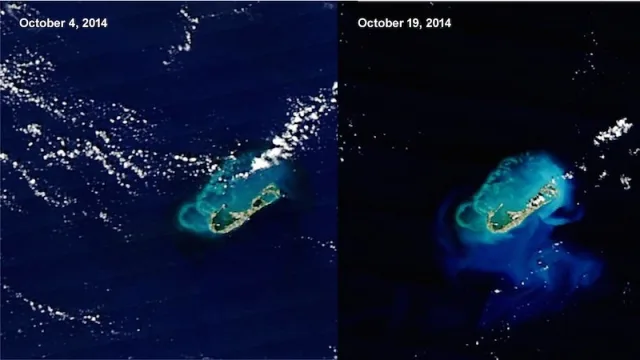
NASA satellites caught signs of some of the storm’s lingering effects when they snapped images of the ocean sediment stirred up by the tempest.
NASA satellies looked down on the island of Bermuda on Oct. 4, 2014, before Hurricane Gonzalo hit, and just after the storm's punishing waves and winds had passed, on Oct. 19. In the after image, the sediment stirred up in the ocean by the storm is clearly visible.
Click image to enlarge. Credit: NASA

When the water is clear, the island’s reefs and the light blue of the shallow waters that surround them are visible. After Gonzalo tore through, sediment plumes fanned out in colors from tan to light green. The nutrients in those plumes may also have fed surface-dwelling ocean plants that made waters appear turquoise, according to NASA.
Nor’easter
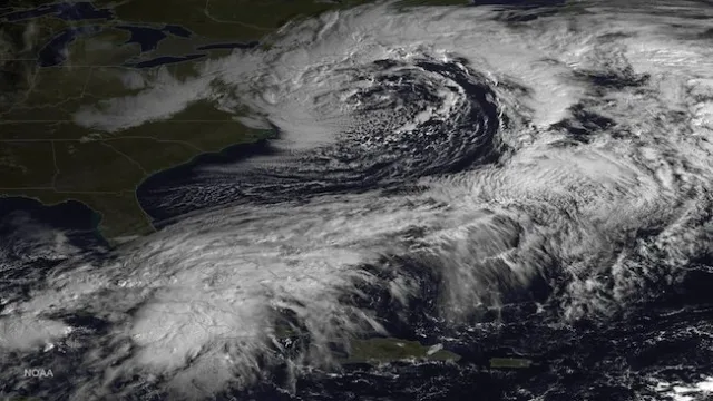
Another type of storm rolled through the Northeast this week, appropriately called a nor’easter.
The GOES East satellite took this image of the swirling nor'easter lashing the Northeast with winds and rain on Oct. 23, 2014.
Credit: NOAA

While nor’easters are often associated with buckets of snow, ones that happen before temperatures have dipped low enough to support snowflakes can still dump a lot of rain. This nor’easter deluged some parts of New England with up to 6 inches of rain and stirred up gusts that knocked down trees. Satellites caught some awe-inspiring views of the swirling storm as it did so.
Beautiful satellite imagery this morning showing our significant coastal storm moving off the coast of New England. pic.twitter.com/EXN3XV2ijo
— NY Metro Weather (@nymetrowx) October 23, 2014
Nor’easters get their name from the strong northeasterly winds that blow across coastal areas ahead of the storm.
Sunny Sky Treat
For those in the U.S. whose skies weren’t obscured by the grey clouds and seemingly unending rains, Thursday afternoon held a special sky treat: a partial solar eclipse.
The eclipse lasted for about three hours and led to plenty of spectacular photos.
We agree! RT @JoshuaTreeNP One word: WOW. #eclipse#SolarEclipsepic.twitter.com/t2kbjqopa2
— US Dept of Interior (@Interior) October 24, 2014
RT @ObservingSpace: Composite pic of the Oct. 23 Partial #SolarEclipse created from the Griffith Observatory feed pic.twitter.com/4QgJT7r4QP
— Emily Lakdawalla (@elakdawalla) October 24, 2014
Solar eclipses happen when the sun, moon and Earth line up in such a way that the moon passes between the other two bodies, covering up either all or part of the solar disk.
Great shot Cody MT @CodyHudson_KNWA: Despite clouds, it was fabulous. Above Boxley Valley, Buffalo National River pic.twitter.com/QJg736n7S6
— Jim Cantore (@JimCantore) October 24, 2014
Just wow! MT @LowlightImages: .@BringMN Partial eclipse 10/23/14 Buffalo MN pic.twitter.com/bfqyIw1sgb
— Jim Cantore (@JimCantore) October 24, 2014
Hopefully the weather will be nice across the country on Aug. 21, 2017, when a total solar eclipse graces U.S. skies for the first time in nearly 40 years.
