News•March 20, 2015
Warm Spring Expected for West, Flooding Risk in East
Spring has sprung, but for parts of the country the season will be a hangover of winter’s extremes: The West looks to stay stuck in hot, dry conditions, and eastern areas walloped by snowstorms could see flooding if the snow on the ground melts too quickly.
The National Oceanic and Atmospheric Administration released its outlook for spring weather across the country on Thursday, and for the next few weeks, it looks to be more of the same. Warm and dry will continue to prevail in the West, while the East will be cool, at least in the near future.
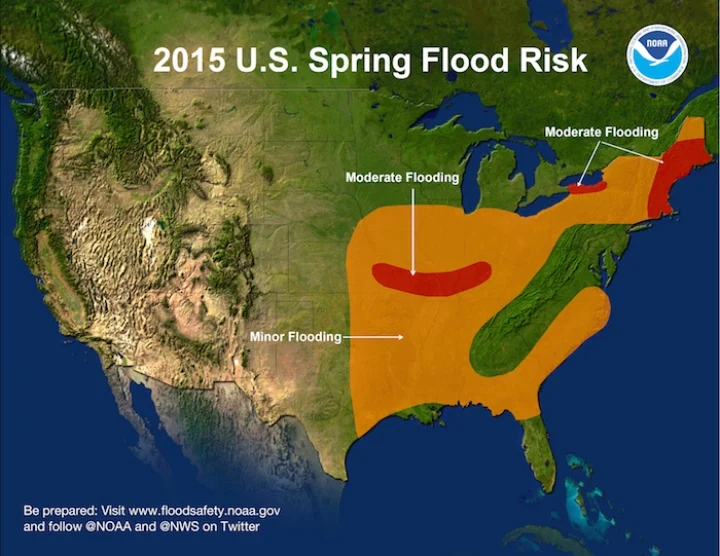
Areas of the U.S. at risk for spring flooding.
Click image to enlarge. Credit: NOAA

But while seasons may vary from year to year, the overall trend for spring in the U.S., as well as the world as a whole, is one of warming, thanks to the excess heat trapped in the atmosphere by accumulating greenhouse gases.
West vs. East
The beginning of spring marks the tail end of the wet season for the West, and once again that season has largely failed to live up to its name. The ridge of high pressure that stayed parked over the region last winter returned this year, keeping temperatures elevated and blocking the storms that could bring much-needed relief.
The winter was a record hot one for California and other western states, which drove up water demand, exacerbating the crippling drought in place there. The warmth also meant that the few storms that did get through dropped rain, even at higher elevations, instead of the snow that is needed to provide meltwater to recharge reservoirs during spring and summer.
RELATEDExperimental Forecast Projects Tornado Season
For the West, A Winter That Has Felt More Like Spring
Spring is Arriving Earlier in the U.S.
While the rains did nominally help recharge those reservoirs, putting them on a slightly better footing than this time last year, the dismal snowpack — even compared to last year’s paltry snow — largely cancels out those gains, USDA meteorologist Brad Rippey said during a press teleconference.
As for the other side of the country, “we have a different story in the east,” NOAA climatologist Jon Gottschalck said during the telecon.
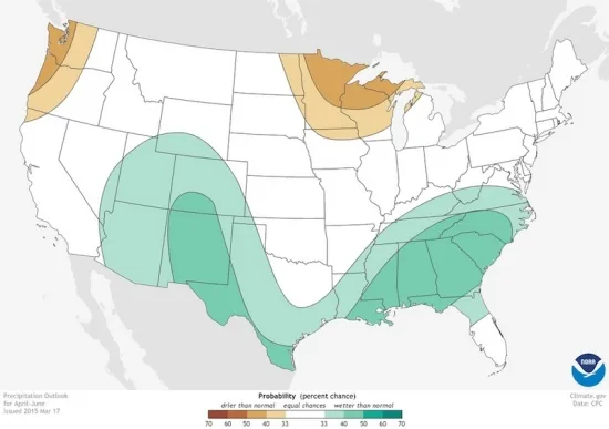
Where chances for above- and below-average precipitation is likely across the U.S. from April through June.
Click image to enlarge. Credit: NOAA

Repeated bouts of bitter cold and sometimes record-setting snowfall kept places like Boston in the deep freezer all season. The substantial snowpack across the northern parts of the East sets up the potential for flooding if spring produces rapid warming and substantial rains — all that water all at once would overwhelm the ability of the ground and streams to absorb it.
The snow still stubbornly sticking to the ground will also influence temperatures in the region while it lasts. The atmospheric pattern that has let Arctic air continually invade the East looks to stay in place for the next few weeks, setting up cooler-than-normal temperatures, which the snowpack will help lower further.
Cold Tames Tornadoes
That pattern of depressed temperatures has also kept tornado activity for the year to date at a record low. No tornadoes have been reported so far in March, traditionally the time of year when severe weather season starts to ramp up. The continued cool weather is likely to keep the lid on tornado activity into April, but beyond that, there’s not a clear signal on what temperatures or storm activity will do.
“Things can change in a hurry and it’s always good to be prepared for that,” Gottschalck said.
A new study that links tornado activity to the climate cycle that governs El Niño events suggests that the very weak El Niño in place right now won’t have much influence on the tornado season. The team behind that study puts a 60 percent chance on the season being a roughly normal one.
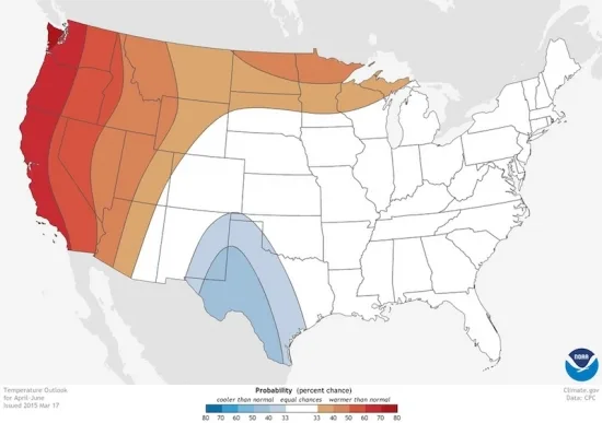
For spring as a whole, the strongest climate signals right now suggest continued above-average temperatures out West and in Alaska, along with wetter-than-normal weather across parts of the southern tier of the country and drier conditions in the Pacific Northwest and Great Lakes.
Where chances for above- and below-average temperatures are likely across the U.S. from April through June.
Click image to enlarge. Credit: NOAA

Spring Warming
While there can be swings from year to year in how cold or warm spring is in certain places, the overall trend in recent decades has been for warmer springs overall. For the nation as a whole, the season has warmed 1.9°F since 1970, or nearly half a degree per decade.
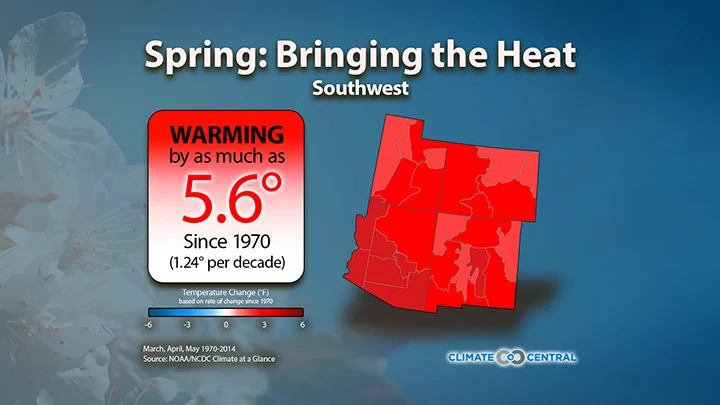
That warming, of course, isn’t uniform, with some regions warming faster than others. The Southwest is the region where spring temperatures have warmed fastest, with temps now about 5°F warmer on average than in 1970. On the other hand, parts of the Pacific Northwest have seen little change in average spring temperatures in that time, illustrating the varied nature of warming.
A Climate Central tool shows how much different regions of the country have warmed:See details for your region:

Not only is spring warming on average, though, it is also encroaching into winter, with the day that the first buds on certain plants are observed arriving three days earlier on average nationally (when comparing the 1991-2010 average to that from 1961-1980). That’s a shift from March 20 to St. Patrick’s Day. It may not seem like much of a change, but wildlife biologists are concerned it could set up a mismatch between plants and the animals that interact with them, such as flowers and pollinating bees.
Once again, the shift is greater in some parts of the country than in others, with some parts of New England seeing spring arrive five days earlier on average — even if it doesn’t feel like it this year.
So spring is here, even if for some areas of the country it felt like spring all winter, and for others it feels like winter will never end.
You May Also Like:
Arctic Sea Ice Hits Record Low Winter Peak
Index Shows Oil’s Climate Impacts Vary Widely
California, Quebec Teaming Up On Climate Change
Two Months In and 2015 Is Record Warm
