News•October 14, 2014
Calif. Heads for Warmest Year As Drought Hangs On

By Brian Kahn
Heavy precipitation fell across parts of the West in September, and while some locations saw top-10 wettest Septembers, much of the region is still mired in deep drought. Part of that is due to the excess heat that’s afflicted the region this year, including what’s been the warmest year to date in California according to U.S. temperature data released on Tuesday.
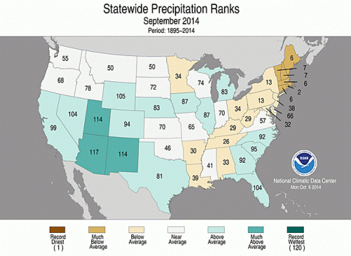
In a role reversal, the normally parched landscape of the Southwest saw record rainfall while verdant New England had a top-10 driest September according to the new data from the National Climatic Data Center (NCDC).
A map showing precipitation ranks by state for September.
Credit: National Climatic Data Center

The U.S. data comes on the heels of global temperature data put out by NASA on Monday showing that the globe had its warmest September on record, adding to the odds that 2014 could become the warmest year on record for the planet. The NCDC will release its global temperature data later this week.
The heavy rains in parts of the Four Corners region came courtesy of the remnants of two tropical systems — Norbert and Odile.
Rainbands associated with Norbert helped Phoenix set an all-time daily rainfall record when 3.3 inches of rain fell in 7 hours on Sept. 8, causing flash flooding across the city. That, coupled with other storms, pushed Phoenix to its wettest September on record with 5.1 inches of rain falling.RELATEDSeptember Was Warmest on Record, NASA Data Shows
Where Is El Nino? And Why Do We Care?
Groundwater is a Drought Lifeline to California Farmers
On the whole, Arizona had its fourth-wettest September, with 2.5 inches of precipitation falling across the state, well above the 1.2-inch average. Utah and New Mexico also had top-10 wettest Septembers.
In comparison, the Northeast was a veritable desert. Every New England state had one of its driest 10 Septembers on record. Rhode Island was the driest, with only 0.9 inches of rain falling — enough to make it the state’s second driest September on record. All of Rhode Island is currently under moderate drought conditions, according to the U.S. Drought Monitor. Large swaths of the rest of New England are experiencing “abnormally dry” conditions.
NCDC scientist Jake Crouch said there wasn’t necessarily one reason for New England’s dry spell, just a combination of factors. However, one of those factors was not the not-quite-formed El Niño. Crouch said in general there were no clear-cut signs of El Niño-like impacts on weather patterns anywhere in the contiguous U.S.
The short-term regional rainfall role reversal doesn’t mean the West’s long-term drought is over or that New Englanders should brace for water restrictions. On the contrary, the monthly Drought Outlook released by the Climate Prediction Center shows the dry conditions in the Northeast are expected to dissipate while drought out West is likely to persist or intensify.
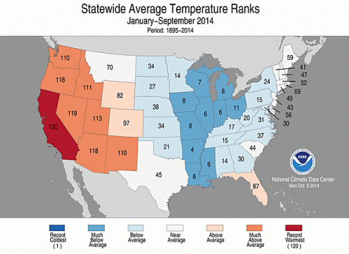
The extreme heat the region has dealt with for the year to-date is part of the reason why. The Southwest has had its sixth-warmest year to-date while the West (encompassing California and Nevada) had its second-warmest.
A map showing temperature ranks by state for the year to date.
Credit: National Climatic Data Center

And California continues to be the state with the biggest departure from normal temperatures. It had a top-10 warmest September, keeping the state on track for its warmest year on record. For the year to date, California has been running 4.1°F above the 20th-century average, well above the previous record set in 1934. Unless temperatures dramatically dip between now and the end of December, the state is likely to have its hottest year on record.
“For the 2014 average temperature to be cooler than the 1934 temperature, the October-December period for California would have to be more than 3.1°F cooler than the 20th century average,” Crouch said in an email. “The October-December average temperature for California has only been that cool two other times in the 120-year period of record (1916 and 1971). In other words, California would have to have an October-December temperature that ranked among the 3 coldest for 2014 NOT to be record warm.”
A persistent ridge of high pressure has kept the state warm and dry, and some research indicates climate change could at least in part be responsible.
Warmer — or at least near-average — temperatures were the norm across almost the entire continental U.S. with Illinois and Indiana the only two states to see below-average September temperatures according to the NCDC. Overall, the U.S. was 1.3°F above the 20th-century average for September of 64.9°F.
You May Also Like:
Scientists: EPA Underestimating Renewables Potential
Pentagon: Climate Change Poses ‘Immediate Risks’
September Was Warmest on Record, NASA Data Shows
Where Is El Nino? And Why Do We Care?